National Trails
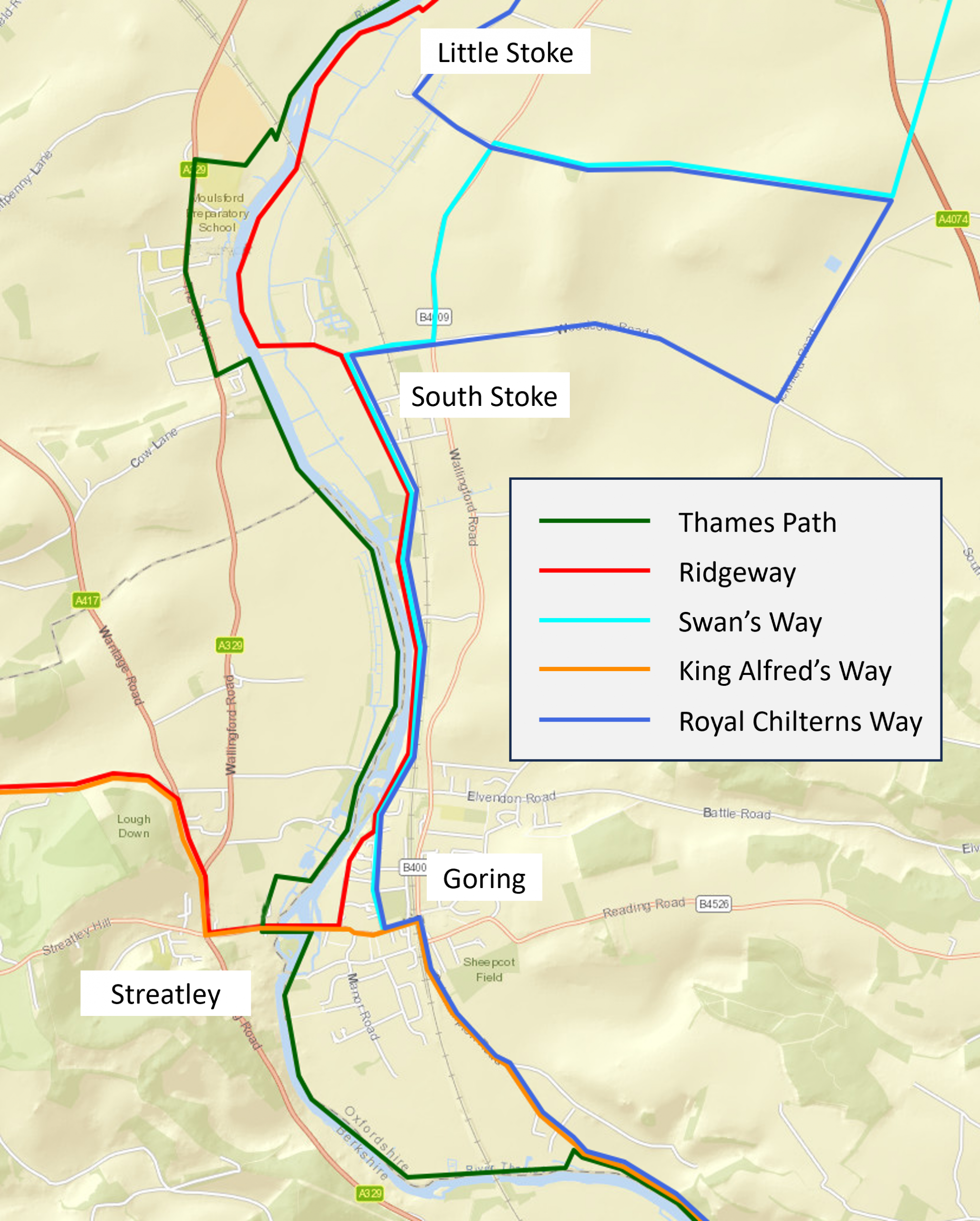
The Goring Gap is where the North Wessex Downs and the Chiltern Hills National Landscapes (formerly known as Areas of Outstanding Natural Beauty) meet. It’s also the meeting point of four long-distance trails, making it a great location for cycling or walking.
Both Thames Path and the The Ridgeway are official National Trails, although neither is legally cyclable in its entirety.
Swan’s Way runs 105 km/65 miles from Goring to Salcey Forest near Milton Keynes. Bridleway throughout. It was designed by the British Horse Society, and is open to cyclists, walkers and horseriders throughout.
King Alfred’s Way is a 350 km/217-mile circular off-road adventure route. West of Streatley it is coincident with The Ridgeway. South of Goring it runs along the bridleway to Whitchurch and Reading, sharing the section to Whitchurch with the Thames Path.
Royal Chilterns Way is a 280 km/174 mi off-road cycling adventure route. It is split into three loops. The 74 km (45 mi) southern loop takes in Reading, Henley, Nettlebed, Stoke Row, North Stoke and Goring. Between Reading and Goring it is coincident with King Alfred’s Way.
The Ridgeway


The Ridgeway is widely held to be Britain’s oldest road, having been used since prehistoric times. The official National Trail runs for 87 miles (140 km) from Overton Hill near Avebury to Ivinghoe.
West of the Thames (Streatley to Avebury), The Ridgeway Trail is open to cyclists and horse riders as well as walkers. The trail is quite rutted in places – a legacy of use by motor vehicles before the were prohibited – and the chalk surface can be extremely slippery in wet conditions. National Trails’ Ridgeway website has a special webpage with information for cyclists.
East of the Thames (Goring to Ivinghoe) parts of the trail are designated as footpaths, so cycling on these is not legally permitted (riding a bike on a footpath is a civil trespass). This includes part of the section from Goring to North Stoke, where it is necessary for cyclists to make a diversion along the B4009 instead. In 2020 The Ridgeway Partnership (Cycling UK and the British Horse Society) launched the Ridgeway Riding Route Project to enable cyclists and riders to travel the route from Goring to Dunstable.
The western section of The Ridgeway and the off-road route to Reading form part of King Alfred’s Way (KAW), a 220 mile (350 km) circular off-road adventure route that connects the Goring Gap to Avebury, Stonehenge, Salisbury and Winchester. The KAW was devised by Cycling UK and launched in 2021. It is not waymarked, but has its own dedicated website from which the GPX route file can be downloaded.
The Thames Path

The Thames Path is a 185 mile (300 km) walking route from the source of the river in the Cotswolds to the Thames Barrier. In the Goring Gap area, it runs on the west bank of the river from Wallingford to Streatley and on the east bank from Goring to Whitchurch (where it crosses the river to Pangbourne). The part of the path from Gatehampton (just south of Goring) to Whitchurch route and is open to cyclists, but the rest of the path in the local area is not.
South of Goring, the Thames Path runs along the bridleway from Gatehampton to Whitchurch, and is co-incident with the King Alfred’s Way. It includes a steep dip into a valley near Coombe Park Farm, so is not very friendly for beginning off-road cyclists.
From Whitchurch to Reading, the Thames Path runs on the Berkshire side of the river, and is footpath.
North of Streatley, the Thames Path follows the west bank of the River Thames, and is footpath.
The trails within Goring and Streatley
The interactive map below shows where National Trails and bike routes run within Goring and Streatley. Zoom in to see local services, zoom out to see details of the routes outside the villages. Click on the four-arrow icon to make the map fill the screen. Hover over and then click on the numbered markers for details of routes to key local places.
For details of local walks, go to the Local Walks section of visitgoringandstreatley.co.uk.
Oxfordshire Online Cycling Map
Cycling UK Oxfordshire has developed an Online Cycling Map, to help people find quieter and safer cycling routes. There are individual maps for Oxford and several towns, including the Wallingford, Benson, Crowmarsh and Goring areas.
The map shows four types of route:
1. Car-free routes (orange) – Route with no traffic, or very little and very slow traffic.
2. Bikeability Level 2 routes (purple) – Suitable for people, cycling at or above the level of training typically received by 11-year olds at school, on quiet roads with simple junctions.
3. Walk your bike only (grey) – Valuable linking routes, where cycling is not permitted, and you have to push. There may be physical barriers as well. These can be a problem for disabled people who use cycles as a mobility aid and who cannot dismount and push.
4. Connecting routes (blue) – Routes that don’t meet our standards above, but are the ‘next best option’ for journeys that many people need to make. These may be busier roads with no cycling facilities, painted lanes or complex junctions, and some will be unsuitable for novices.
Not every route is shown, we have chosen the most useful ones aiming to make sure schools, shops and other key destinations are joined up. It has been crowd-sourced from over 60 volunteers in towns across Oxfordshire, many of them Cycling UK members.